Copernicus data is often presented as "free". For a student, a journalist or a small association, this word does not answer all the questions: do I need to create an account, how long does a download take, what to do with a large file, and how do I know if the image is usable? The Copernicus Data Space Ecosystem provides a browser and programming interfaces. Open access is an important step forward; the cost of connection, storage, computation, and expertise remains real. A good data policy is only useful if people can do the work until the final result is achieved.
Start small, with a specific question
The browser allows you to select an area, a time period, and a data set, and then view scenes without immediately downloading all the files. To study a specific area of Douala, for example, you need to narrow the scope, choose a relevant date, and check for clouds. A too broad search returns a large number of images, consuming time without improving the response. Before clicking "download," note the product, its processing level, and its identifier. This trace makes it possible to reproduce a map.
Spatial resolution is a trade-off. A pixel of several meters may be sufficient for a large change in vegetation, but not for identifying a specific drain or house. Optical images are affected by clouds; other products require different interpretation skills. Free access does not remove the physical limitations of the instrument. A highly zoomed screenshot does not create detail that does not exist in the data.
The browser and the API do not serve exactly the same purpose.
The Browser makes it easy to explore and get initial results. An API allows you to repeat a query, document parameters, and handle multiple dates, but it requires understanding authentication, formats, and response structure. The service's beginner's guide describes these steps. Automating a bad selection of scenes too early simply produces more bad maps. It's better to manually check a few cases, then move to the script when the question and quality control are stabilized.
Services may apply quotas or usage policies that change over time. Customers should read current terms and conditions before promising unlimited capacity to a team or partner. Even when the source data is available at no cost, hosting a large dataset, maintaining backups, and processing time can result in costs. Documentation should distinguish these expenses from the price of the data itself.
A reproducible path with low bandwidth
A team with limited connectivity can prepare the area of interest and the dates offline, then use the browser to quickly check a few scenes. They download a subset suitable for analysis rather than entire archives, if the service and license allow. Metadata and a small thumbnail are retained with the results. Raw data, processing steps, and the final image are kept separate. This organization allows the study to be resumed when the connection drops, and to explain where each pixel shown to the public comes from.
A publication must cite the collection, the organization, the acquisition dates, and the processing applied. The citation and attribution rules of the provider should be checked, as well as the rights of an interface capture. An open data set does not allow removing its context or publishing sensitive information without consideration.
A hidden cost: checking the result
Downloading an image is not the final step. You need to understand the metadata, remove low-quality pixels, verify the coordinates, and retain the operations performed. An organization that pays for a day of access can then spend several days checking the map. This time investment is rarely mentioned in open data announcements. It should be included in a project’s budget, along with storage and training.
Sharing a result also involves maintenance. If a vendor updates a product, it is important to know which version was used for the article. If a person leaves the team, the access and scripts should not disappear with them. A small file describing the data source, parameters, and limitations makes the work transferable. It also allows the reader to distinguish a reproducible treatment from a simple snapshot chosen for its beauty.
Choose the tool according to the need
To explain to students the effect of a cloud on a Sentinel-2 image, a few scenes in the Browser are sufficient. To compare dozens of dates over several years, an API or a computing environment may be necessary. For a land-use planning decision at the parcel level, even a long Sentinel series may not have the desired accuracy. The choice of software comes after the definition of the question, not before.
Accessibility also concerns language and interfaces. Documentation in English alone can hinder a French-speaking team; a pedagogical translation must therefore preserve the exact names of products and settings entered in the software. A bilingual tutorial could help, provided it is updated when the service changes. The best indicator of actual accessibility would be the number of teams able to reproduce an analysis and report its limitations, rather than just the number of downloads.
A practical test of actual accessibility
To measure access, we can assign the same small task to multiple teams: find a Sentinel-2 scene in a defined area, check for clouds, record the product ID, and export a properly labeled figure. We note the time spent, the volume downloaded, the errors encountered, and the steps that require assistance. A team with a slow connection can succeed by preparing its criteria in advance; a well-equipped team can fail if it does not read the metadata. The test would show which training or interface improvement is most valuable.
This protocol can be repeated after a short training in French. If the time decreases and the citations become more accurate, there is some initial evidence of usefulness. However, it is important to distinguish the effect of training from the effect of a better connection or new software. Access is not just about opening the site: it includes the ability to verify and communicate a result without relying on a single expert.
The costs that come back every year
A one-off project may use a borrowed computer. A sustainable service must provide for maintenance, backups, documentation, script updates, and training of new personnel. The storage of large datasets can quickly exceed the initial need; keeping only the products and settings necessary for the question reduces costs. Service quotas and usage conditions should be reviewed regularly, as they may change. The free availability of raw data does not guarantee the free availability of an operational infrastructure.
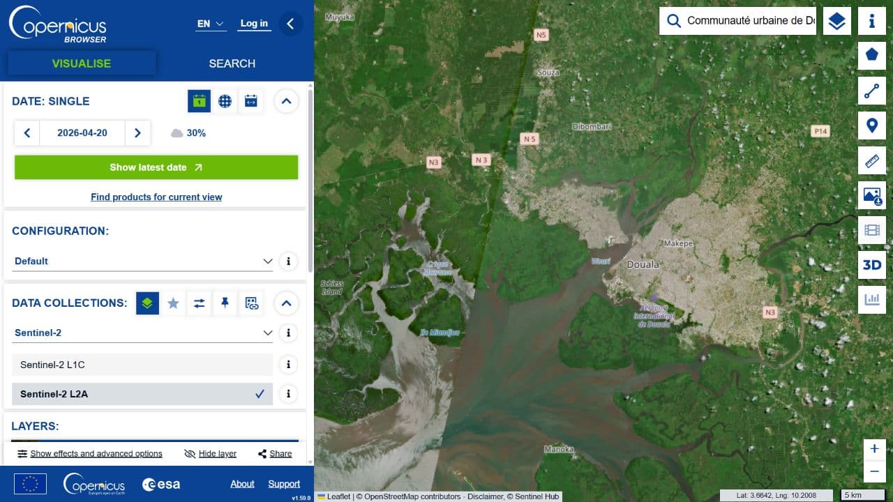
The opening image shows a real-world test in the anonymous Browser, centered on Douala and set to Sentinel-2 L2A in natural colors on April 20, 2026. The corresponding scene can be found in the catalogue under the identifier S2B_32NNK_20260420_0_L2A; the RECA folder dedicated to viewing images of Douala provides a careful comparison with a scene from 2025. This capture proves that the interface can display the area; it does not demonstrate that downloading, analyzing, or accessing it from a slow connection school is easy.
A team may publish in an appendix the file sizes and the time required to run the exercise on their connection. This practical information helps another institution to estimate whether the tutorial is actually accessible under their conditions.
What this changes – or does not change – for Central Africa
Access to Copernicus removes a major barrier for African researchers and journalists. It does not replace GIS training, field observations, or an appropriate connection infrastructure. Our original capture and scene identifier provide a verifiable starting point for Douala. A full tutorial should still measure download times, document common errors, and test the workflow with multiple connection qualities. This text remains an explanation of the costs and methodology, not a demonstration that all users can already easily exploit this data.