
Understanding our planet from space
Earth observation is one of the RECA Space Agency's main areas of development.
Through this program, RECA is working on the use of data from observation satellites and the progressive development of capabilities to better understand the transformations of our environment.
The objective is to put space technologies at the service of concrete issues: climate change, plant cover, land use, relief, water resources, urbanization, agriculture and natural risk management.
A program to monitor our environment
Satellites make it possible to observe the Earth's surface repeatedly and over vast territories.
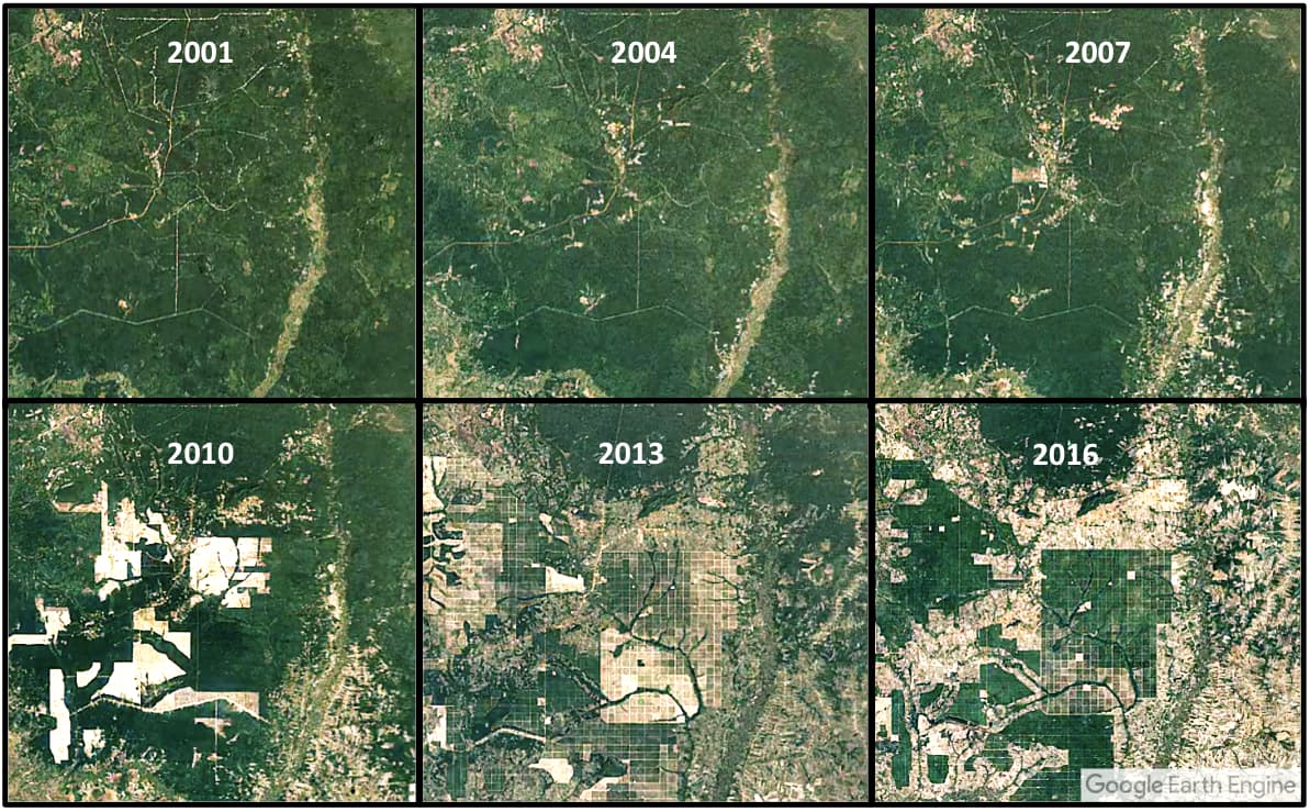
Unlike observation only from the ground, satellite imagery makes it possible to compare the same region over time and to identify changes that are sometimes difficult to perceive on a human scale.
The RECA observation programme is concerned in particular with several categories of data:
changes in vegetation cover;
occupation and use of land;
Development of urban areas.
relief and topography;
water resources;
Agricultural areas
surface temperatures; and
the development of climatic phenomena;
detection and monitoring of certain areas exposed to natural hazards.
This information can then be exploited with image processing tools, geographic information systems (GIS), remote sensing and artificial intelligence.
The climate under surveillance
Space observation plays an essential role in the study of climate.
Satellites are used to monitor parameters such as surface temperature, cloud cover, vegetation, snow and ice, oceans and various environmental indicators.
Across Cameroon and Central Africa, these data can contribute to a better understanding of ecosystem transformations and the effects of climate variability.
RECA is particularly interested in the exploitation of these data in order to produce information useful for research, spatial analysis and decision-making.
Observe the relief and transformations of the territory
Earth observation is not limited to conventional images taken from space.
Satellite data can also be used to produce digital elevation models and to study the topography of a territory.
Landforms are essential for many applications: mapping, urban planning, agriculture, watershed management, flood risk analysis and infrastructure planning.
Combined with geographical data, this information makes it possible to construct a more accurate numerical representation of the territory.

Agriculture and vegetation
Vegetation is also an important indicator of the state of a territory.
Multi-spectral satellites can observe different bands of the electromagnetic spectrum that are not all visible to the human eye.
This information can be used to calculate different vegetation indices, such as the NDVI, to study the density and evolution of vegetation cover.
In particular, these methods can be applied to crop monitoring, drought analysis, forestry studies and monitoring of land use change.
For RECA, this field represents a meeting point between space observation, agriculture, environment and data science.
Monitoring of waters and coastal areas
Satellites can also provide important information about water resources.
In particular, imagery is used to identify and monitor changes in the extent of lakes, rivers, wetlands and reservoirs.
In coastal regions, satellite data can also be used to study coastal evolution, coastal zone occupancy and certain environmental phenomena.
For a country like Cameroon, which has both a sea front, many rivers and large wetlands, these applications are of particular interest.
RSA-1: demonstrator of the observation
As part of its technological development, RECA is working on RSA-1, a demonstrator intended to explore the various technological building blocks needed for a future Earth observation capability.
RSA-1 is part of a step-by-step approach: understanding the constraints of an observation mission, studying the necessary components and developing the skills to gradually move from the analysis of satellite data to the design of space systems.
The demonstrator thus constitutes a field of experimentation around several areas:
acquisition and processing of observation data;
design of embedded systems;
communications with a ground station;
power supply and energy management;
determination and attitude control;
storage and transmission of data;
the processing of images;
geolocation of observations;
exploitation of data from the ground segment.
The goal is not simply to build an object to be placed in orbit.
The aim is to gradually develop all the skills required for an Earth observation mission, from the on-board system to the exploitation of the data.
From spatial data to decision
The interest in Earth observation lies not only in the quantity of images available.
True value emerges when this data is turned into actionable insights.
A chain of observations can be represented in a simplified way as follows:
Satellite → Acquisition → Transmission Ground → Station → Processing → Analysis Geospatial → Data → Decision
RECA is working on this integrated approach to bring space technologies closer to terrestrial needs.
A satellite image can become a vegetation map.
A time series can reveal the evolution of an urban area.
Topographical data can help to identify areas prone to flooding.
Repeated observations can help track the evolution of an ecosystem.
It is this transformation of spatial data into useful information which constitutes one of the fundamental objectives of the RECA observation programme.
Building an African Observation Capacity
Earth observation is now one of the most accessible and useful fields in the space sector.
It does not only require knowing how to build a satellite.
It also requires skills in geomatics, remote sensing, computer science, artificial intelligence, signal processing, data analysis, meteorology, mapping and space communications.
For RECA Space Agency, the development of these skills is an essential step towards building a sustainable space capability in Cameroon.
RSA-1 is part of this vision: to start by mastering technologies, developing skills, experimenting on the ground and gradually preparing future generations of observation systems.
Observing the Earth from space is therefore not just a matter of technology.
It's a way of better understanding our territory to better anticipate its evolution.